Interactive School Threat Mapping & Geolocation Alerts
Precision and Clarity in Every Alert
Included in our Plus subscription, the Interactive Mapping with Geolocation feature offers unparalleled precision and clarity in monitoring and responding to potential threats within your school.

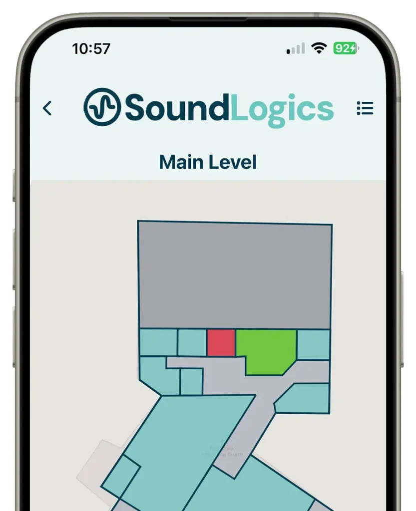
- Building Mapping: Visualize your entire school layout with detailed, interactive maps that display every room and corridor.
- Pinpoint Sensor Activation: Instantly identify the exact location of activated sensors triggered by noise alerts or key fob alerts.
- Real-Time Updates: Receive real-time updates on the interactive map, ensuring you have the latest information to make informed decisions quickly.
- Enhanced Coordination: Improve coordination and response times by knowing precisely where an incident is occurring, allowing for swift action by staff and safety personnel.
- User-Friendly Interface: The intuitive design makes it easy to navigate and utilize the mapping feature, ensuring seamless integration into your existing safety protocols.
Enhance Your School’s Safety with Precision
Enhance your school’s safety and response capabilities with the Interactive Mapping with Geolocation feature, part of our comprehensive Plus subscription. With precise location tracking and real-time updates, you’ll always have a clear picture of your school’s safety status.
Interactive safety mapping
Modern schools require more than basic notifications during emergencies. Administrators, school resource officers, and safety personnel need immediate visual context to understand where a situation is developing and how to respond efficiently. Sound Logic’s interactive mapping technology combines real-time sensor activity with geolocation intelligence to help schools improve threat detection in schools and emergency coordination. Dynamic mapping capabilities provide staff with a more accurate understanding of incident locations throughout campus environments. This added visibility helps schools streamline emergency communication efforts while supporting faster, more informed response strategies during critical situations.
Visualize threats in real time
Whether responding to a potential school intruder, suspicious activity, or a developing safety concern, staff can quickly identify the affected area inside the building and communicate more effectively with first responders. By pairing interactive building maps with live sensor alerts, schools gain a clearer operational picture during high-pressure situations. Location-based visibility helps reduce confusion during rapidly evolving incidents by giving authorized personnel access to more precise information in real time. This enhanced level of coordination supports faster decision-making while helping schools strengthen campus-wide communication and emergency response efforts.
Advanced school safety mapping
When seconds matter, knowing the precise location of an activated alert can significantly improve response time. The system allows staff and emergency responders to identify where a threat event originated, helping reduce confusion during emergency situations. This enhanced visibility supports faster lockdown decisions, improved communication between departments, and more coordinated incident management across the school campus. The mapping interface can also help schools document and review safety incidents after an event, giving administrators additional insight into response procedures and building activity patterns.